(Based on USP Granted 10268740)
Introduction
Modern infrastructure runs on location. Trains, gates, vehicles, sensors, maintenance crews, and passengers are all connected by place and time. Yet the data sits in silos. Maps live in one system, IoT readings in another, work orders somewhere else. When something changes, teams scramble across tools.
A 3D geo-engine solves this. It becomes the single place to align spatial data, live signals, and operational rules. The outcome is simple: faster decisions, better safety, and lower cost.
This blog explores the concept behind USP Granted Patent 10268740 — the 3D GeoEngine A2S3 — and how it powers smarter transit and city operations.

What is 3D GeoEngine A2S3
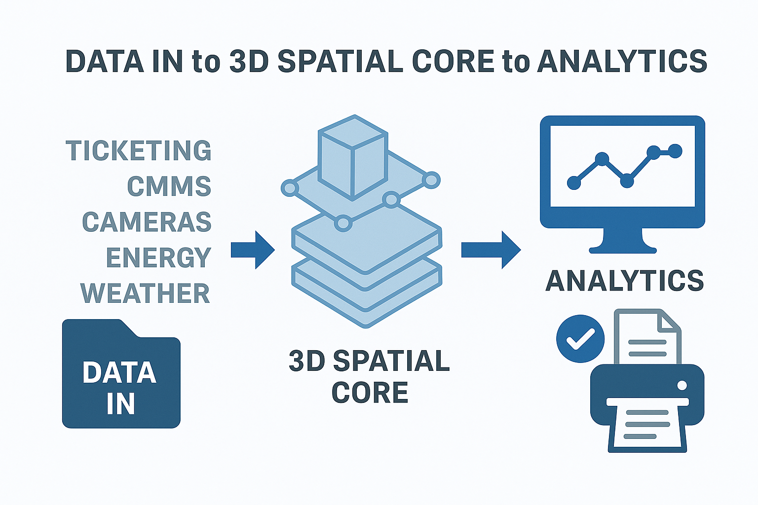
Our granted patent describes a software core that:
- Ingests diverse geospatial layers (CAD, BIM, GIS), sensor streams, and schedules.
- Aligns everything a 3D coordinate system with time stamps.
- Analyzes conditions with rules, thresholds, and AI models.
- Simulates “what if” scenarios like flows and closures.
- Serves results to dashboards, mobile apps, and automated actions.
Think of it as the brain that powers an operational digital twin. It unifies existing tools around location and time so teams can act in one view.
At the heart of GeoEngine A2S3 lies a spatial-temporal data engine capable of processing millions of signals from different sources and aligning them with both coordinates and time. The platform’s backend combines three key elements:
- Data Ingestion Layer: Connects to sensors, APIs, GIS databases, CAD and BIM models, and live feeds like ticketing and CCTV. It cleans, normalizes, and structures them into a common spatial model.
- Core Engine: A real-time reasoning layer that stores and computes relationships between objects. For example, if a train is delayed, it automatically recalculates crowd density in connected corridors.
- Visualization and Control Layer: Presents the entire network as an interactive 3D environment with dashboards, heat maps, and live alerts.
The design ensures speed, precision, and modularity. Users can deploy it in cloud or on-prem environments, plug in custom models, and connect AI prediction services.
Use Cases Across Mobility and Facilities
- Subway systems: Map platforms, tunnels, sensors, and timetables in one 3D view. Detect crowding and plan closures efficiently.
- Airports: Align gates, baggage systems, and energy controls. Balance flows, reduce queue time, and schedule maintenance.
- Smart city corridors: Fuse traffic signals, cameras, and curb assets. Simulate traffic flow or emergency response.
- Large campuses: Track assets, routes, and indoor positioning to improve maintenance and wayfinding.
Each deployment uses the same foundation — location and time — to build situational awareness for operations.
Key Features and Capabilities
- 3D plus time: Unifies spatial and temporal data for real-time monitoring.
- Multi-source integration: Works with CAD, GIS, IoT, and ticketing systems.
- Actionable insights: Provides automated alerts and rule-based responses.
- Scalable architecture: Runs across single sites or entire city networks.
- Secure and compliant: Role-based data access and full audit trails.
These capabilities make GeoEngine A2S3 not just a visual tool but an operational intelligence framework for physical systems.
Metrics That Matter
- Queue and dwell times by zone
- Throughput per corridor, gate, or platform
- Alert rate and response time for safety rules
- Energy usage versus occupancy and schedule
- Maintenance KPIs like mean time to repair
Each metric links to physical coordinates, providing context behind every number.
Future Vision: AI-Driven Urban Intelligence
While today’s GeoEngine connects maps and machines, its future lies in AI-assisted decision making. As cities evolve, data will move faster than humans can interpret. Predictive analytics, generative design, and adaptive automation will become critical.
Imagine a system that not only tracks where congestion is happening but predicts it hours before it occurs. Or one that simulates how a weather forecast impacts airport gate assignments. With AI integration, the engine could recommend actions rerouting flows, adjusting energy loads, or alerting staff without waiting for manual input.
This evolution turns GeoEngine A2S3 into a living digital ecosystem, where spatial intelligence meets machine learning. The same patent principles modularity, spatial alignment, and real-time reasoning — form the foundation of this future-ready infrastructure.
Conclusion
3D GeoEngine A2S3 turns scattered maps and signals into a living operational picture.
It helps teams see what is happening, test what might happen, and guide what should happen.
The result is smoother movement, safer spaces, and clearer decisions — all grounded in location and time.


